|
GOING
BACK TO PLACES THAT I
HAVE NEVER BEEN
Being
a Field Guide to Hanoi and Dien Bien Phu for
Historians,
Wargamers and the More Discerning Type of Tourist
by
Peter
Hunt
Part
Two: Dien Bien Phu
My
own exploration of
Dien Bien Phu
was not
conducted in a completely systematic manner but, for the sake of clarity, we
will not follow my route but divide the battlefield into three areas ~ east
of the river, west of the river and the outlying positions ~ with separate
articles for each.
I
would stress again that these articles are intended more for the buff than
for the casual reader and I’m assuming that you know a bit about the
battle and know what was happening to who, when, where and why.
Thus I shall concentrate on relating the ground to the events and,
hopefully, give you some pointers so that you can best organise your own
trip. If you are not going to
make it to the battlefield sometime soon I hope that anyway I can give you a
few insights that will be useful.
Getting
There and Finding Your Way Around
By
all accounts
Dakotas
were an
unpleasant way to travel, having a disconcerting tendency to drop suddenly
in airpockets over mountains.
Vietnam
being full of
mountains French soldiers tended to prefer the “Toucan”, Junkers 52
Trimotors which were slower, but a lot more stable.
The modern traveller has neither option but it still gladdens take
heart to fly to
Dien Bien Phu
on a plane
with propellers ~ a French built ATR 70.
The
flight from
Hanoi
takes little
more than an hour. Try and get a
window seat in Row D because on the normal approach the view to the East
will give you an instant familiarisation to
Dien Bien Phu
today.
I was sitting in the window seat on the other side.
The planes usually take off and land from the South so, looking West,
the first thing I saw was a “Bison” Chaffee tank sitting on the Huguette
position next to the airstrip I was instantly back in 1954.
After a remarkably easy baggage reclaim I was soon in the car to the
hotel and totally dumbfounded. The
reason is simple. I knew that in
1954 there were 112 houses in
Dien Bien Phu
.
I also knew that in 2002 the population was about 24,000.
My mind hadn’t put the two concepts together.
Instead of the empty valley dominated by hills and the mountains
beyond that I have had in my mind’s eye for the last 30 years I was on a
four lane highway through a major urban development.
Getting my head around this was quite a task and I spent most of my
first afternoon trying to work out which hills were which.
When I flew out I had the view over the town that you would have had
from Row D on the way in. The
hills stand out as elevated, undeveloped islands in the sea of urban sprawl
and this aerial familiarisation is a lot clearer and easier than working
things out at ground level.
Although
you can get guide pamphlets to
Dien Bien Phu
’s
attractions I couldn’t get a decent street map of the place.
Beware, the map in “Lonely Planet” was apparently drawn by
someone who was both directionally, and dimensionally challenged and who was
just passing through anyway. To
try and put things in better context please have a look at these two maps of
Dien Bien Phu
in 1954 and
today.
.
Taking
my lead from the “Lonely Planet” I stayed in the Muong Than Hotel which
they said was the best hotel in town. It’s
a bit far out, closer to Beatrice than to Dominique, but it has very helpful
staff and provides reasonably clean, two star comfort, with hot water,
aircon, telly and sit down toilets. There
is a swimming pool, billiard room, bar of sorts, massage establishment and
restaurant that includes mountain mouse, chow meat, porcupine meat, sanbar
deer and wild boar on its menu so you needn’t starve.
“Lonely Planet’s” second choice is the Dien Bien Phu Hotel
which is more centrally located but doesn’t look as nice as the Muong
Than, although I wasn’t able to check out the rooms.
Getting
around you have the same options open to you as in
Hanoi
except that
taxis only operate from the main hotels.
The inner valley positions are all within walking distance (although
it can be hot, so drink lots of water, which you can buy everywhere,) or you
can hop a motorbike between spots. To explore further afield you will need
to hire a motor bike, ($20 US a day, bargainable,) or an air-conditioned
taxi ($50 US a day,) I chose the latter, didn’t haggle and had a splendid
time.
To
find things I used the maps in Bernard Fall’s “Hell in a Very Small
Place”, individual maps of the strong points downloaded from the “Dien
Bien Phu Infos” website
and the 1:250,000 sheet map “Dien Bien Phu” that you can buy for $3 US a
sheet in Hanoi. The battlefield is well marked. There are large
“monument” style markers and permanent maps at many of the major points,
and practically all the sites are marked by smaller “milestone” type
markers. Whilst the larger
markers include a text explanation (in Vietnamese of course,) that often
identify the position using the French codename, most of the markers use the
Viet Minh designation. Also Viet Minh units are usually described by their
title rather than by their regimental number as used in western sources.
This can be a little disconcerting so I will shortly add an annex to this
article giving “translations” of French and Viet Minh designations.
Finally, if you need to orient yourself as I did the easiest way is
to find the Bailey Bridge and take compass bearings on the hills.
The bearings will also given in the Annex.
.
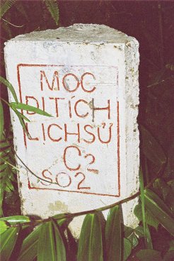
Milestone Battle
Marker
The
flight from
Hanoi
arrives and
leaves in early afternoon so I spent an afternoon, a morning and a whole day
on the interior positions; and another day trip to visit the outlying
positions. This was adequate but
another full day for the interior positions would have been nice.
I was relatively lucky with the weather but unless you are visiting
in the dry season (November to March,) an extra day will also give you some
flexibility in case of a not unlikely downpour or an airplane delay.
So although I spent three nights in
Dien Bien Phu
I would
recommend four. After all I live
near enough and fully intend to go back, you may not have that luxury.
Armed
with your maps, compass, stout boots, (for hill climbing and paddy bashing,)
long trousers and long sleeved shirt, (for mossies and moving through the
undergrowth,) insect repellent, camera and water you are now ready for your
exploration of Dien Bien Phu.
East
Of The River
The
Dien Bien Phu
Museum
The
obvious place to start is the Museum. This
is open from
8:30 a.m.
to
4:30 p.m.
with a siesta
from about
11:00 a.m.
to about
2:00 p.m.
You buy tickets for the Museum and the Eliane position from the
little shop just outside the entrance to the Museum.
This shop also sells bits of “genuine” parachute silk (at $2 US I
thought it was worth a punt, maybe it really is genuine,) and some
battlefield relics, mostly rusted personal items.
A real bargain in this shop are commemorative badges and stamps.
The stamps go for 5000 Dong each so a full set costs about $2 US.
On EBay these sets go for between $10 and $30 US.
The
museum consists of one large, (very badly lit,) exhibition hall, two outside
display areas, one for French kit, one for Viet Minh; and a separate
exhibition hall dedicated to the T’ai people of the area.
The
main hall has lots of interesting pieces.
My favourites were General De Castries’ bath, (a real metal one, I
don’t know if it was flown in or salvaged from the old Governor’s House
on Eliane,) a Japanese 75 mm Meiji 41 Regimental gun with its distinctive
tubular trail used by the Viet Minh, (Raventhorpe do a nice model of
these),
one of the 6 barrelled Katyusha rocket launchers used in the final stages of
the battle and the contents of a “Lazy Dog” Bomb, the precursor of
today’s sub-munition weapons. Also
worthy of note are a manikin of a typical Viet Minh soldier at
Dien Bien Phu, wearing a
cape of camouflaged parachute silk; and a fanion of a Foreign Legion Unit.
The hall also contains a smaller version of the battle diorama that
is in the
Museum.
The
Viet Minh weapons outside are probably not from the battle.
After all the 351st Heavy Division was not in the business
of setting up Museums and when they left they took their 105 mm howitzers
and 37 mm AA guns with them. There
was still a war to fight. But
for all that the weapons in the museum are good examples of the sort of
equipment the Viet Minh used.
On
the other hand there can be little doubt about the French weapons outside.
There is an 8” Howitzer (one of four originally in the valley,) in
relatively good condition. A
“Bison” Chaffee tank in quite good state, along with two more tank
wrecks, and the rusting wreckage of six GMCs, six jeeps, a Dodge 1½ tonner
and a Dodge weapons carrier.
Pay
particular attention to the serial details engraved on the tube of the 8”
howitzer. This barrel was made
at the WVT Arsenal (tube number 14459) in 1954 ~ i.e. it was brand new at
the battle. Along with the 37 mm
Flak used by the Viet Minh this is a good example of the proxy aid given by
both superpowers to the protagonists in Indochina
.
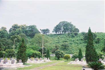
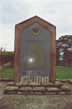
The Main
Cemetery
Directly
across the road from the Museum is the main cemetery.
Cemeteries are supposed to be sobering places, and because of their
symmetry military cemeteries are even more so.
This one is no exception to this rule and here lie the Viet Minh
heroes of the battle, in serried ranks even in death.
The cemetery is not the largest on the battlefield, the two on either
side of Gabrielle way to the north are bigger, but because of its location
this cemetery is the focus of the Vietnamese commemoration of their dead.
Main Cemetery - outside
wall
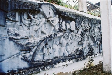
The
decorative garden between the road and the cemetery is not well maintained.
Buffalo
roam through
what should be lawns and pools. But
the cemetery itself is well looked after.
Built like a medieval fortress, complete with a moat and ornamental
gateway, the outer wall is covered with mouldings and frescos showing the
events of the battle ~ a sort of pictorial history.
It is the inner wall that is more sobering however – cloistered and
cool even in the heat and humidity of the day this is the Vietnamese version
of the American “wall” on the Mall in
Washington
.
It contains the names of the Viet Minh fighters who fell at the
battle. Just like its Washington
counterpart
you see people looking for the names of their comrades and relatives and
votive offerings are left for them.
As
well as a place to reflect upon the cost of war and the sacrifices for
liberation, the cemetery had three special points that struck me.
Firstly, in a special plot on the northern side, is the grave of Phan
Dinh Giot, the first Viet Minh hero of the siege who fell in the assault on
Beatrice.
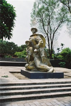
Secondly
there is the focus of the cemetery at the eastern end which consists of an
altar flanked by two larger-than-life sculptures of Viet Minh fighters.
These are carved in a rugged “socialist realism” style and depict
assault troops again wearing the distinctive parachute silk capes of the
battle. The sculptures are
covered in fading gilt paint, that looks a bit shabby close up, but when the
afternoon sun catches the stone and the gilt the effect is quite dramatic.
 |
 |
|
The Viet Minh fighters |
E2 and Tank Bazailles
look down on the cemetery |
The
third dramatic thing about the place is simply the view of Eliane 2 just
across the road to the north. Although
the lowest of the “Five Hills” E2 was one of the most hard fought over
and from the cemetery it is easy to see why.
The hill itself dominates the low ground on which the cemetery stands
and its flanks rise like a near vertical wall to the cemetery.
It is a very fitting backdrop to the last resting place of the men
who fell on it.
Eliane
2
Eliane
2 is the best preserved of all the hill positions.
It is the main site commemorating the battle from the Vietnamese
point of view and the hill also has deep significance for the French.
This is because of the nature of the battle for the hill itself.
On most of the other positions the battles consisted of ferocious
Viet Minh assaults which either overwhelmed the position after horrendous
losses or were repulsed with horrendous losses.
If a position was taken the French would either retake it with a
counterattack, only to lose it later to another Viet Minh attack; or the
position would be given up completely. Eliane
2 was a different situation. The
initial Viet-Minh assault stalled on the top of the hill and the French,
realising that if the hill fell all of
Dien Bien Phu
would fall,
determined to pay any price to hold on.
As a result the battle for Eliane 2 came to resemble more the trench
warfare in World War I or the “meat grinder” operations of Korea than
the normal pattern of warfare in Vietnam in general or Dien Bien Phu in
particular. Thus the French and
the Vietnamese were locked in combat on Eliane 2 for 38 days.
Unable to go over the top of the hill the Viets eventually went under
it, digging a mine and filling it with explosives salvaged from a shot down
French bomber. When the mine was
exploded and the hill finally taken on
6th May, 1954
Dien Bien Phu
had only one day to live.
The
entrance to E2 is paved and well signposted off the main road.
The top of the hill is fenced off and you have to pay to get in at
the museum ticket office. However,
the rest of the hill is open to all. Before
you climb the hill however, note two things at the bottom.
The first is a bunker right next to the junction of the hill road and
the main road which the Vietnamese called “Manikin Knoll” because of the
shape of the decapitated tree on it. This
bunker does not feature significantly in French or English language accounts
of the battle but “The capture of Hill A1” in Vietnamese Studies No. 3
points out that it was decisive because the initial attack on the hill on
30th March, 1954
included a flanking move to the south of the hill to cut it off.
This stalled because of fire from the bunker.
Because the Manikin Knoll held, the French still had a route to feed
reinforcements up the hill. Because
they could do that the hill held. Because
the hill held Dien Bien Phu
held.
The
other thing to look for here is the large descriptive plaque by the road.
Like the other plaques on the battlefield it includes the details of
the action and the Viet Minh units involved and is decorated by the badges
of the French units involved. Nothing
odd about this but if you look closely at this plaque you will see that it
includes the badge of the main non-communist Vietnamese unit in the battle
the 5th, Vietnamese Parachute Battalion (5 BPVN) which was known
as the “Bavouan,” and which fought as well any French or colonial unit
during the battle. I was
strangely pleased by this little sign that, although during the war the
nationalist Vietnamese units were disparaged as “puppet troops”, when it
came to commemorating the battle the Vietnamese recognised their erstwhile
enemy compatriots as worthy opponents.
.
Viet Minh
Memorial on E2
As
you enter the enclosure on the top of the hill the first thing you see is a
marble monument commemorating the battle, behind which are the remains of
the cellar of the old French Governor’s House.
Although when the French occupied the valley they demolished the
house for building materials, they fortified the cellar.
It was this masonry cellar, held by a few Moroccan tirailleurs, which
stalled the Viet Minh initial attack on the top of E2.
Careful reading of “The Capture of Hill A1” reveals that this was
because of a rare failure in Viet Minh battlefield reconnaissance.
Although the Viet Minh must known that this was the site of the
Governor’s House they did not put two and two together regarding the
underground masonry defences and the assault units did not have effective
enough demolition charges to deal with them.
The
trench works around the summit have been cemented to save them from erosion
so they are a lot tidier than they would have been in the siege but,
presumably, the shape and depth of the trenches is a fair representation.
To the south of the summit tank “Bazailles” looks out broodily
over the cemetery. The tank was
immobilised during a French counter attack on the hill and was then used as
a machine gun nest for the rest of the siege.
.
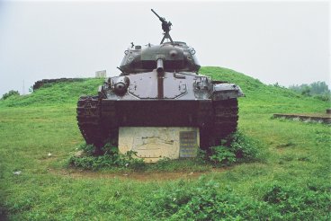
Tank
Bazailles in the rain
From
the eastern fence of the summit enclosure you get a perfect view down the
glacis of the hill, an open slope that the French called the “Champs
Elysee” and up which the Viet Minh assaults had to charge through the
French fire. Beyond you can see
“Phoney
Mountain” and “Bald
Mountain”, two hills
which the French did not occupy and which the Viets used as their base of
fire. Where the road now runs
(incidentally to the best restaurant in Dien Bien Phu), between E2
and the two hills, used to run the gully in which the Viet Minh prepared
their attacks. As such it was
the obvious target for French artillery and Vietnamese soldiers were cut
down in their hundreds here. All
the side streets in
Dien Bien Phu
are unlit and
I walked down this particular road on a moonless night during the “hungry
ghost” festival when a few old ladies were burning offerings to appease
the restless souls of the dead. I’m
not a nervous person but it was still very spooky!
Because he relied on the use of the gully and failed to prepare
approach trenches through this killing zone the Viet Minh commander of the
initial assault was held responsible for the failure and “removed.”
Before
you leave the summit look to the north and you can see most of the “Five
Hills” on which the defence of
Dien Bien Phu
rested, and
how they relate to each other. The
tallest is Dominique 2, now crowned by its tower which appears to dominate
the whole battlefield. In
between Dominique 2 and E2 you can see the mass of Eliane 1 and 4.
Look carefully and you will see that although D2 is much higher than
the Elianes there is enough dead ground on E1 and 4 to protect most of them
from fire from D2, and these two hills partially protect E2 from D2.
Thus, although the French lost D2 the Elianes were still, barely,
tenable. However if E2 were to
fall, flanking fire from it would make E1 and E4 untenable and vice-versa.
Thus the French were able to hold on by their fingernails until
almost the end.
You
leave the summit by the way you came up and follow the fence around the
south side. This brings you back
to the Champs Elysee and the mine crater, which has been cemented to stop
erosion. You can then walk down
the hill where there is a plaque to mark the entrance to the mine tunnel and
a re-creation of the approach sap from the gully (now road) to the mine.
This walk will leave you with a good idea why the battle for E2 went
as it did. It was formed by the
shape of the hill itself, which is rather like a door wedge.
The North, South and West slopes are steep, and the summit is near
the West, French, end. However,
the Eastern approach is relatively gentle.
Thus the Viet Minh assaults were channelled into this killing zone
which was covered by direct French fire from the summit and E4; and by
zeroed in artillery both from the main position and from Isabelle to the
south. That E2 was held so long,
and eventually taken, is a tribute to the determination of the soldiers on
both sides of this battle.
|
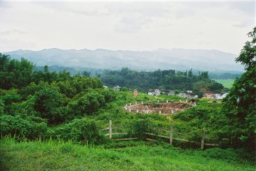
|
|
The
"Champs Elysee" looking down from the French position
over
the mine crater to "Old Baldy" |
Elianes
1 and 4
E1
and 4 are two hills joined by a low saddle.
E1 fell to the Viet Minh on the first day of their assault on the
“Five Hills” on March 30th. Realising that the hill was vital the French counter-attached and
retook it but, like on D2, they had to withdraw because, due to Cogny’s
lack of action during his “Night at the Opera,” there were no
reinforcements to allow the French to hold onto the ground that they had
retaken at such cost. However,
the French soon came to realise that E4 could not be held without E1 and so,
on April 10th, they launched a counterattack and retook it.
The Viet Minh however were just as aware of E1’s importance and,
under a withering bombardment, they launched their own counterattack and
took half the hill. The French
threw in their last reserves ~ companies from French, Foreign Legion and
Vietnamese paratroop battalions.
In
my favourite part of one of my very favourite books, “Hell in a Very Small
Place”, Bernard
Fall describes what happened next:
“Then
something very strange happened. Something
which, in the recollection of the thousands of men who heard it that night,
had rarely happened before in
Indochina
. As the hundred
Legionnaires and French paratroopers stormed across the low saddle between
E4 and E1, they began to sing.”
The
French and the Legionnaires had marching songs going back to their founding.
But the Vietnamese paratroopers of the Bavouan had:
“[no
such]… rousing marching song that could be shouted at the top of one’s
lungs if only to drive out one’s fright.
But there was one song which was then still in the cultural inventory
of every Vietnamese schoolboy, and that was the French National Anthem, the
Marseillaise. As the Vietnamese
paratroopers in turn emerged on the fire-beaten saddle between the hills
there suddenly arose, for the first and last time in the
Indochina
War, the Marseillaise. It
was sung in the way it had been written to be sung in the days of the French
Revolution, as a battle hymn of the
French
Republic
. It was sung
that night on the blood stained slopes of Hill Eliane 1 by Vietnamese
fighting other Vietnamese in the last battle France
fought as an Asian Power.”
This
account sends little tingles up my spine every time that I read it.
So it was very important to me to find the saddle between E1 and E4.
This turned out to be so easy that I didn’t believe it and had to
go back twice to convince myself I was in the right place!
Sadly
the Western face of E1 has already been cut back for building work but E4 is
untouched. Oddly enough this is
a disadvantage because although there appears to be a path to the top of E4
it is completely overgrown and I could only get about half way up.
You might have better luck in the dry season when the ground cover
and bushes will not be as thick. Even
so the bushes are above head height so I don’t think that you will see
much from the top.
.
The "Saddle" today
The
“saddle” is in fact the road between the two hills.
The reason that I didn’t believe it was because it is hardly a
saddle at all. In my minds eye I
had pictures of the paras climbing a high steep slope.
Although the sides of the hills are quite steep, probably more so now
than in 1954, neither hill is particularly high and the “saddle” is only
a few metres above the level of the plain below.
There is a path to the top of E1 but this has been cut off by the
slope works and the other approaches are overgrown like E4.
As you proceed down the road ~
Giot Street
~ which
actually encircles the South, East and North faces of E1 you can get a good
feel for the lie of the land. The
flanks of E1 are quite steep and there is enough dead ground to protect it
from D2. However from both E1
and E4 the side of D2 is open. That
is why the three hills were so interdependent.
Dominique
2
Dominique
5, the linking position between D2 and E1/E4 has disappeared under
development, but you can’t miss D2. It
is by far the highest hill in the central position at 550 meters and it is
now crowned by a radio mast. A
paved road leads to the top, a steep but not difficult walk, but then I was
not wading through mud with a combat pack and rifle, and no one was shooting
at me either. The road follows
the South flank of the hill so you get good views of E1, E2 and E4 and then
curves around the eastern and northern sides at the peak.
This gives you views out to Beatrice and, providing its not raining,
you should be able to pick out the monument on the top of that hill which
will bring home to you its relative isolation.
But
what about the view to the West? From
the top of D2 you would get a splendid view of the whole of
Dien Bien Phu
position.
I say “would” because the top of the hill is taken up by a
telecommunications centre of which the mast is the most obvious part.
Like all such facilities in
Vietnam
it is closely
guarded and off limits to tourists. The
area outside this facility is heavily wooded so most of the western views
are blocked.
Once
you get over this disappointment the things that strike you are D2’s
height and steepness. The
Western and Southern faces, (i.e. those facing the Viet Minh,) are the
steepest. The present road runs
anti-clock wise around the hill from the “6 o’clock” position until it reaches the summit at the “11 o’clock” position. In 1954 there
was a path going direct to the summit from the “9 o’clock
position”
and a jeep track from Route 41 reaching the summit and the “11 o’clock” position. Since these two
routes were more or less direct they must have been much steeper than the
present road.
Thus
the Viet Minh had the hardest approaches and did well to take the hill in
their March 30th attack, even though its defenders wore some of
the least determined units in the garrison.
The French did equally well to retake it, but it is a very big hill
in
Dien Bien Phu
terms and
would probably require the best part of a battalion to hold it.
Here its very steepness was a disadvantage because there was so much
dead ground that would require a lot of troops to properly cover the
approaches with fire, especially after D1 and E1 on its flanks had fallen.
But if the French had had the reinforcements to do this I can see no
reason why D2 should not have held out like E2.
No doubt the Viet Minh would have continued their assaults as they
did on E2. No doubt the
bloodletting would have been horrendous.
But, since Viet Minh morale was close to cracking at the end of the Battle
of the Five
Hills, another meat grinder on D2 might have been enough to tip the balance.
Also the morale effect on the French garrison would have been
significant. D2 is really the
only hill that can be clearly picked out from anywhere in the French lines.
With D2 in Viet Minh hands the whole of the French central position
was under direct observation and much of it within sniper range.
Had it been held it would have offered protection to some of the main
position and would also have served as a visible, and potent, symbol of
French defiance. However, this
is just a “what if”.
The
French didn’t have the reinforcements.
They were sitting on an airfield in Hanoi awaiting Cogny’s order.
Thus, having retaken the hill the French were forced to give it up
again. The Paratroop
reinforcements that could have dropped on 30th/31st March were eventually fed in on April
1st to 4th.
Too little, too late.
Dominique
1
D1
was the northern anchor of the Five Hills being located between Route 41 and
the river. It was a poor
position to hold, exposed to Viet Minh fire on two sides with lots of
undergrowth nearby to give the enemy cover.
It is really just the westernmost, and lowest, eminence of a series
of hills running from the river all the way to Beatrice, the most easterly
of all the French positions. Once
Beatrice fell D1 was very vulnerable. Although
its southern face could be protected from D2 the same Viet Minh juggernaut
that overran the larger hill made short work of D1.
Much
has changed at D1 today. It is
now sandwiched between Dien Bien Phu’s main market and a road.
It is marked by the usual “milestone” markers but both the faces
of the hill have been cut back for development and the road and the top is
overgrown. Having clambered up
the embankment by the marker I was unable to find a path to the top.
Perhaps you will have better luck at the end of the dry season.
The “Non-Hill”
Positions
The
remaining positions east of the River, E3, E10; and D3, D5 and D6 have
disappeared under developments. I
could find no markers for these. But,
as you walk towards the Bailey Bridge on your left you will see Dien Bien
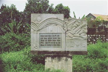
Phu’s other, more colourful, market and on your right, in a small bog, you
will see a large monument type marker. This
marks the site of Piroth’s bunker at E12.
From
the French perspective
Dien Bien Phu
is a tragedy
and in it Piroth is probably the most tragic character.
A one armed artillery veteran he was supremely confident of his
gunners’ ability to beat off any Viet Minh attacks.
However the overwhelming artillery superiority that the Viet Minh
demonstrated at the beginning of the battle neutralised his guns and
destroyed most hope for the garrison; and with it Piroth’s personal and
professional pride too. Piroth
was a man of honour and took full responsibility for his misjudgement on the
most direct way. Unable to cock
a pistol because he had only one hand, he held a grenade to his chest and
committed suicide in his bunk.
 |
|
"Piroth's
Memorial" disconsolate in its bog |
Although
much of the view is blocked by buildings if you look North – East from
this site you are looking over the ground where the Senegalise gunners of Lt
Brunbrouck’s battery of the 4th Colonial Artillery fired over
open sights at the victorious Viet Minh descending from D1 and D2 on that
first night of the Battle of the Five Hills.
Had they reached the river and the bridges all of the later struggles
for the hills would have been irrelevant.
Dien Bien Phu would have fallen five weeks earlier than it did. But
Brunbrouck’s vollies stopped the assault that night.
I hope that it was some consolation to the Shade of Piroth that it
was the artillery that saved Dien Bien Phu.
Unlike
the Viet Minh you can cross the Bailey Bridge and explore the positions West
of the river in the next part of this article.
go to part one
back to
vietnam go
to part three
|